

A site plan is often the first drawing a construction professional looks at before setting foot on a project, yet many site teams treat it as a formality instead of a working document. The truth is, a site plan tells you how a building sits on its plot: boundaries, access, levels, services and how the structure relates to everything around it. In simple terms, if you cannot read a site plan properly, you cannot set out a building correctly, position drainage correctly, or confirm the project is even compliant. This guide breaks down how to read a site plan the way an experienced architect, engineer or site supervisor does, from boundary lines to NCA compliance in Kenya. Whether you are a civil engineer, architect, quantity surveyor, mason or site foreman, this is a skill you need early in your career.
Quick Answer: A site plan shows the position of a building on its plot, including boundaries, setbacks, access, levels and services. Read it by confirming the scale and north point first, then checking boundaries and setbacks, then studying levels, drainage and service connections, and finally cross checking it against the architectural and structural drawings.
What is a Site Plan and Why Every Construction Professional Needs to Read One
A site plan is a scaled drawing that shows the plot of land, its boundaries, and the position of the proposed building within that plot. It is different from a floor plan, which shows the inside of the building, and different from a location plan, which shows where the plot sits relative to the surrounding town or area.
Honestly, a lot of site disputes come from someone not checking the site plan properly. A contractor sets out a wall too close to the boundary, a plumber runs a soak pit into a neighbour’s land, or a mason builds a perimeter wall on the wrong line. The site plan is the document that prevents all of that, so every professional on site, not just the architect, needs to be able to read it with confidence.
The Key Elements Found on Every Site Plan
A properly prepared site plan carries specific information that you should check every time, in the same order, so nothing gets missed. Here is what to look for and why it matters on site.
| Element | What It Shows | Why It Matters on Site |
|---|---|---|
| Boundary lines | The legal edges of the plot, usually with bearings and distances | Confirms the building does not encroach on neighbouring land |
| North point | Orientation of the plot and building | Guides sun path decisions and helps you align the plan with the actual ground |
| Setback lines | Minimum distance the structure must sit from each boundary | A legal requirement, not a design suggestion |
| Existing and proposed levels | Ground levels (spot heights) across the plot | Used for earthworks, drainage falls and foundation depth decisions |
| Access and road reserve | Entry points, driveways, road width | Confirms vehicle access and compliance with road reserve rules |
| Services | Water, sewer, power and drainage connection points | Coordinates MEP works with civil and structural teams |
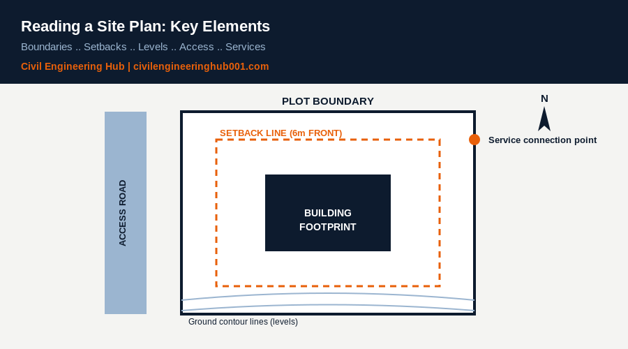
How to Read Boundaries, Setbacks and Building Lines
Start with the boundary. Every site plan should carry a survey reference, usually the Land Reference (LR) or Title number, and the boundary dimensions should match the survey beacons physically present on site. That means is worth noting.. before any setting out begins, the site plan boundaries should be checked against the actual beacons on the ground, not assumed.
Next, identify the setback lines. In most Kenyan counties, residential plots require a front setback of 6 metres from the road reserve and side and rear setbacks that vary with plot size, typically 3 metres, though this depends on the specific county’s development control policy and zoning. The Kenya Building Code and NCA regulations both require that structures respect these setbacks before any approval is granted, so this is not something a site team can adjust on their own judgment.
A building line is different from a setback in that it can sometimes be more restrictive, set by the local authority for a specific area, such as along a major road. Always check both.
Understanding Levels, Contours and Drainage on a Site Plan
Levels on a site plan are shown as spot heights or contour lines, and they tell you how the ground falls across the plot. This is the information that drives your cut and fill decisions, your foundation depth, and most importantly your drainage design, because water must be directed away from the building and toward the correct drainage point, never toward a neighbour’s plot.
A site plan is usually drawn at a specific scale depending on the plot size and the amount of detail required. Knowing the scale tells you how to measure real distances directly off the drawing using a scale rule.
| Scale | Typical Use |
|---|---|
| 1:100 | Small residential plots, detailed site layout |
| 1:200 | Standard residential and small commercial plots |
| 1:500 | Larger plots, estates, institutional sites |
| 1:1000 or smaller | Large developments, road and infrastructure projects |
Site Plans and NCA Requirements in Kenya
In Kenya, a site plan forms part of the mandatory documentation submitted to the county government and, where required, to the National Construction Authority for project registration. The NCA Act requires that registered contractors and projects above a certain threshold be recorded before construction begins, and the site plan is one of the reference documents used to confirm the project location and scope.
For any professional signing off on site works, it matters that the approved site plan on file matches what is happening on the ground. If a variation changes the building footprint or setbacks, that change needs to go back through approval, not just get built because it seems minor. This is one of the most common compliance gaps on small to medium projects in Kenya, and it is avoidable if the site team treats the site plan as a live compliance document, not a one time approval formality.
Common Mistakes When Reading a Site Plan on Site
The truth is, most site plan errors are not about misunderstanding the drawing, they are about skipping steps. Here is what to watch for:
| Mistake | Consequence |
|---|---|
| Not verifying boundary beacons before setting out | Structure built partly outside the legal plot |
| Ignoring setback lines during construction | Non-compliance, possible demolition order |
| Missing service connection points | Costly rework of drainage or water lines |
| Using an outdated site plan revision | Building against a superseded layout |
How a Site Plan Connects to the Architectural and Structural Drawings
A site plan never works alone. Once you have confirmed boundaries, setbacks and levels, the next step is cross checking the site plan against the architectural floor plan and the structural foundation layout. The building footprint drawn on the site plan must match the footprint on the architectural drawings exactly, down to the dimension. If it does not, someone has made a revision on one drawing without updating the other, and that gap is where costly setting out errors come from.
For structural teams, the site plan levels feed directly into foundation design decisions. A sloping plot with a level difference of even half a metre across the footprint changes how you approach stepped foundations, retaining requirements and excavation volumes. For MEP professionals, the service connection points on the site plan determine where your incoming water line, sewer line and power connection physically enter the building, which affects internal routing long before first fix begins.
This is why, on a well run project, the site plan is one of the first documents reviewed in a coordination meeting, alongside the architectural and structural sets, not treated as a standalone approval document that gets filed away once construction starts.
Frequently Asked Questions
Q: What is the difference between a site plan and a location plan?
A site plan shows the detailed layout of a specific plot, including the building position, boundaries, setbacks and services. A location plan is a smaller scale drawing showing where that plot sits within the wider town, estate or road network, used mainly for identification and approval purposes rather than construction detail.
Q: Do I need NCA approval before starting site works based on a site plan?
Yes, for most registered construction projects in Kenya, NCA registration and county approval of the site plan and building plans should be secured before construction begins. Starting works without this exposes the client and contractor to stop orders, penalties and potential demolition, so this step should never be skipped to save time.
Q: What scale is a typical residential site plan drawn to?
Most residential site plans in Kenya are drawn at 1:200 or 1:100, depending on the plot size and the level of detail needed. Larger developments or estates are typically drawn at 1:500 or smaller. Always confirm the scale printed on the drawing rather than assuming, since scale errors lead directly to setting out errors.
Reading a site plan properly is not a task for the architect alone. Every professional who touches a project, from the civil engineer setting levels to the mason building the boundary wall, needs to understand boundaries, setbacks, levels and services before work starts. In simple terms, the site plan is your first line of defence against costly, avoidable mistakes. Make it a habit to read the site plan before every major activity on site, not just once at project kickoff, and always confirm you are working from the latest approved revision.
Want more practical construction knowledge delivered directly to you?
Subscribe to our YouTube channel: https://www.youtube.com/@TheCivilEngineeringHub-001
PS: Join our engineering WhatsApp community for daily learning at +254731393520