

If you have ever stood on a road construction site in Kenya watching graders and tippers move mountains of soil, you have probably wondered how anyone knows exactly how many cubic meters are being cut or filled. The truth is, this is not guesswork. It comes down to one calculation method that every civil engineer learns early: the Average End Area Method.
In simple terms, this method estimates the volume of earthworks between two cross-sections by averaging their areas and multiplying by the distance between them. It is the backbone of every earthwork schedule on a KeNHA road project, and getting it wrong means either paying a contractor for soil that was never moved, or underpaying for work that was.
Quick Answer: The Average End Area Method calculates earthwork volume by averaging the cross-sectional areas at two consecutive stations, then multiplying that average by the distance between them. It is the standard method used on Kenyan road projects for cut and fill quantity estimation.
What Is the Average End Area Method and Why Engineers Use It
Road alignments are not flat. As a road climbs a hill or crosses a valley, the amount of cutting or filling changes from one point to the next. Engineers cannot measure volume directly on a curved, changing ground surface, so they break the alignment into cross-sections at fixed intervals, usually every 20m or 30m depending on the terrain.
Each cross-section has a calculated area of cut or fill. Honestly, the simplest way to estimate the volume of earth between two of these sections is to average their areas and multiply by the distance separating them. That is the entire idea behind the method, and it works because road sections rarely change area dramatically over short distances.
The Formula Behind the Average End Area Method
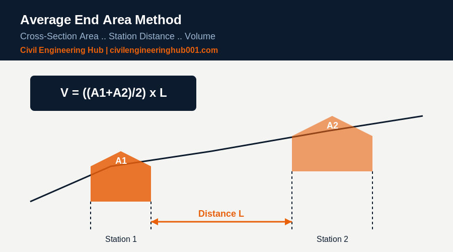
The formula is simple once you understand where the numbers come from:
V = ((A1 + A2) / 2) x L
Where:
- V = volume of earthwork between the two sections (cubic meters)
- A1 = cross-sectional area at the first station (square meters)
- A2 = cross-sectional area at the second station (square meters)
- L = distance between the two stations (meters)
This is applied repeatedly along the entire alignment, station by station, and the volumes are summed to get the total cut or fill quantity for the project. The Kenya Roads Board and KeNHA Road Design Manual Part III both reference this method as the standard for earthwork quantity computation on trunk and rural road projects.
A Worked Example: Step-by-Step Calculation
Here is how this looks in practice, using a hypothetical 100m section of road with cross-sections taken every 20m.
| Station | Chainage (m) | Cross-Section Area (m²) | Distance to Next Station (m) | Volume (m³) |
|---|---|---|---|---|
| 1 | 0+000 | 12.5 | 20 | – |
| 2 | 0+020 | 15.0 | 20 | 275.0 |
| 3 | 0+040 | 18.2 | 20 | 332.0 |
| 4 | 0+060 | 14.8 | 20 | 330.0 |
| 5 | 0+080 | 10.5 | 20 | 253.0 |
| 6 | 0+100 | 8.0 | – | 185.0 |
Total volume for this 100m stretch = 275.0 + 332.0 + 330.0 + 253.0 + 185.0 = 1,375 m³. This is the number that goes into the BOQ, and it is the number a quantity surveyor will use to certify payment. Every site engineer should be able to reproduce this table from raw cross-section data without hesitation.
Common Mistakes That Distort Earthwork Volumes
The truth is, most volume disputes on Kenyan sites do not come from bad math. They come from bad inputs. A few things to watch for:
- Inconsistent station intervals. Mixing 20m and 30m spacing without adjusting the formula per segment throws off the entire schedule.
- Ignoring transition zones. Where cut changes to fill, the area at that point is not zero unless properly interpolated.. this needs the “grade point” calculation, not a straight average.
- Using outdated survey data. If the ground has been disturbed by earlier plant movement, the cross-section no longer reflects reality.
- Rounding too early. Round only the final volume, not the intermediate areas, or errors compound across a long alignment.
Prismoidal Correction.. When the Average End Area Method Falls Short
In simple terms, the Average End Area Method slightly overestimates volume when the ground is highly irregular, because it assumes a straight-line change in area between stations when the actual change is often curved. For high-precision work, engineers apply a prismoidal correction:
Cp = (L / 12) x (A1 – 2Am + A2)
Where Am is the area at the midpoint between the two stations. This correction is subtracted from the average end area volume. On most road projects in Kenya, the difference is small enough that KeNHA accepts the simpler method for payment purposes, but it matters on projects with very uneven terrain or where volumes are large enough that a 2 to 3 percent error becomes financially significant.
Comparing the Two Methods
| Factor | Average End Area Method | Prismoidal Method |
|---|---|---|
| Calculation effort | Simple, fast | More complex, needs midpoint area |
| Accuracy on regular terrain | High | High |
| Accuracy on irregular terrain | Can overestimate | More accurate |
| Standard use in Kenya | Default for KeNHA road BOQs | Used for verification on complex sections |
| Software support | Universal in AutoCAD Civil 3D | Available but less commonly automated |
Kenya-Specific Practice on Site
On Kenyan road sites, cross-sections are typically generated from total station or drone survey data, then processed in AutoCAD Civil 3D or similar software, which automates the average end area calculation. But honestly, every site engineer and site supervisor still needs to understand the manual method. Software gives you a number. Understanding the formula tells you whether that number makes sense before you sign off a payment certificate.
The Kenya Roads Board specifications and KeNHA’s Road Design Manual both require earthwork quantities to be verified against survey cross-sections before interim certificates are approved. This is where quantity surveyors and civil engineers work together.. the QS measures the BOQ item, but the engineer confirms the volume was calculated correctly from the field data.
How Software Handles This on Modern Sites
Most contractors working on KeNHA and county road projects now generate cross-sections digitally rather than by hand. A drone survey or total station traverse produces a digital terrain model, and software like AutoCAD Civil 3D overlays the design template on that terrain at every station to compute cut and fill areas automatically.
This is faster and reduces transcription errors, but it does not remove the engineer’s responsibility to sanity-check the output. In simple terms, if the software reports a volume that looks unusually high or low compared to what you observe on the ground, the first thing to check is whether the station interval was set correctly and whether the existing ground surface used in the model is current.
Students and young engineers building toward structural or highway design work should still practice manual average end area calculations before relying fully on software. Understanding the formula is what lets you catch a software error before it becomes an expensive one on a certified payment.
Why This Matters Beyond the Calculation Itself
Earthwork often represents one of the largest single cost items on a road project, sometimes 20 to 30 percent of total contract value on projects that involve significant cutting through hilly terrain. A small systematic error in volume calculation, repeated across kilometers of alignment, can translate into millions of shillings in disputed payment.
This is why site engineers, quantity surveyors, and resident engineers on Kenyan road projects treat earthwork measurement as a joint responsibility rather than something left entirely to the survey team. The engineer who understands both the formula and the field conditions is the one best placed to catch problems before they reach a payment certificate.
Frequently Asked Questions
Q: Is the Average End Area Method accurate enough for payment certificates?
Yes, for most road projects with regular terrain and consistent station intervals, it is accurate enough and is the standard method accepted by KeNHA. It becomes less reliable on very irregular terrain, which is when a prismoidal correction should be applied to avoid overpaying or underpaying a contractor.
Q: What station interval should I use for cross-sections?
Most Kenyan road projects use 20m intervals on straight, regular terrain and reduce this to 10m on curves, steep grades, or areas with rapidly changing ground profile. Closer intervals mean more accurate volumes but more survey and processing work.
Q: Can this method be used for building excavation, not just roads?
Yes. The same principle applies to basement excavation or large foundation digs, where cross-sections are taken across the excavation and volumes computed the same way. It is less common there because building excavations are usually simpler shapes, but the formula does not change.
The Takeaway
The Average End Area Method is not complicated, but it is unforgiving of sloppy inputs. Get your cross-section areas right, keep your station intervals consistent, and know when a prismoidal correction is worth the extra effort. That is the difference between an earthwork schedule a quantity surveyor trusts and one that gets challenged at every payment certificate.
If you are still building this skill, practice on real KeNHA cross-section drawings before you touch a live site schedule. The formula is easy. Reading the ground correctly is the actual skill.
Want more practical construction knowledge delivered directly to you?
Subscribe to our YouTube channel: https://www.youtube.com/@TheCivilEngineeringHub-001
PS: Join our engineering WhatsApp community for daily learning at +254731393520